"

Yuraygir and Solitary Islands Coast Walk
Text and photosGreg Keaney
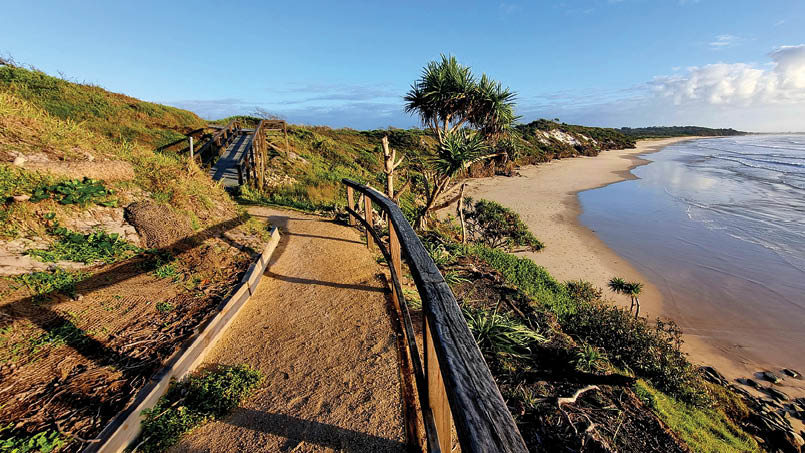
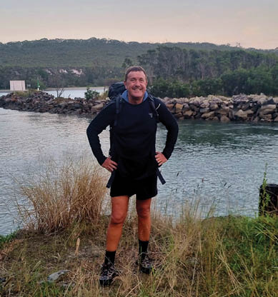
Day 1: Angourie sunrise
4 | Bushwalk June 2024
L ao Tzu famously said the journey of a thousand miles begins with a single step. Last year I took that first step on a thousand-mile, thousand beaches coastal hike, aiming to walk every beach and every headland of the magnificent coast of New South Wales. A pilgrimage I can truly believe in.
It’s no marathon odyssey, though. I broke the thousand miles into one week 'chunks' to allow me to align the walk with my ‘normal’ life (and, fortunately, to provide lots of pleasurable opportunities for planning, reading, preparing and improving for the next stint). This article recounts my third 'chunk', having completed Coolangatta to Ballina in chunk 1 and then Ballina to Angourie in chunk 2. Chunk 3 is the stretch from the small surfing town of Angourie to the land of the big banana, Coffs Harbour, via Yuraygir National Park (the longest stretch of national park protected coastline in NSW) for four days, and then a further two along the northern section of the Solitary Islands Way.
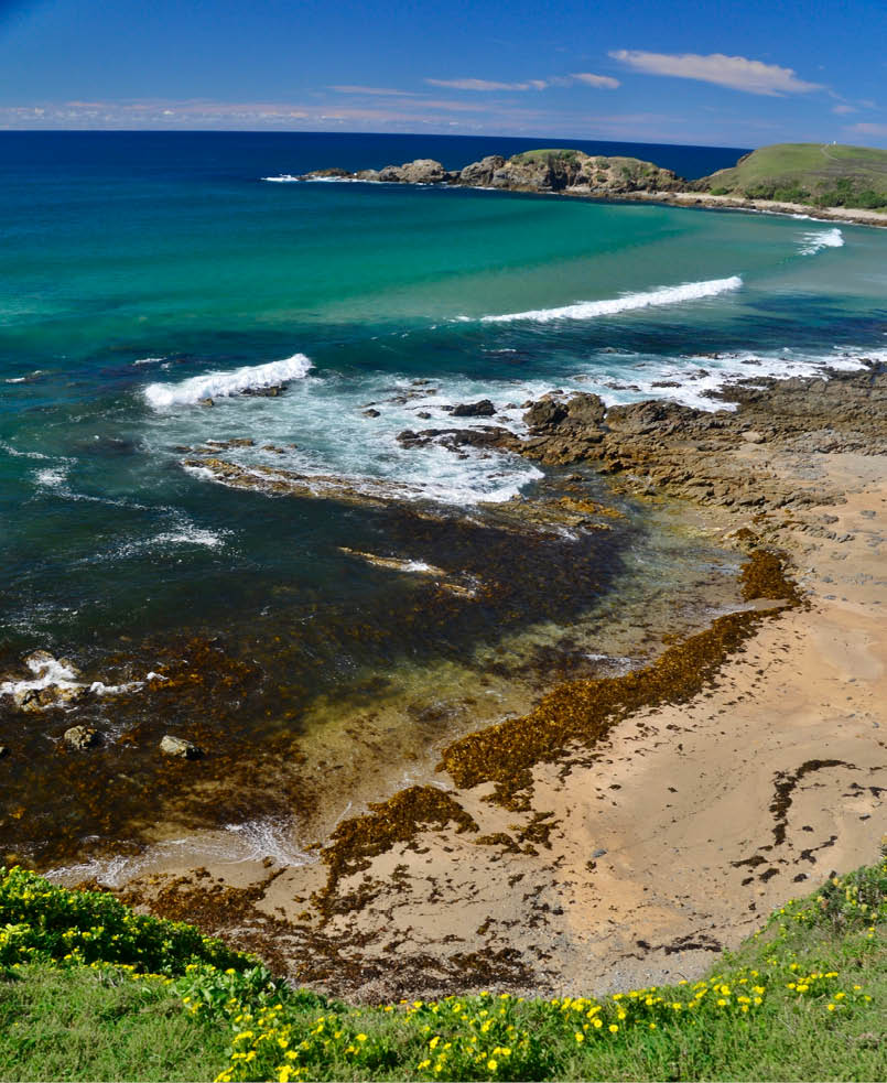
Day 1: Angourie Point to Brooms Head18km, 6 hrsAngourie, or 'tail feather', is the jumping-off point for the Yuraygir Coastal Walk. My overnight 'backpacker express' bus arrived at Yamba at 5.00 am – excellent timing for an early morning coffee and a lucky lift with a dawn surfer to arrive at Angourie Point just in time for a perfect sunrise.
There’s always a peculiar moment for me at the start of each chunk – it’s the first 'official step'. Of course, there are plenty of 'pre-official' steps - in this case, getting off the bus, walking to the café, getting into and out of the car, walking to the lookout platform to take a few sunrise snaps… But there comes an actual conscious moment – a dramatic, fully aware mindful 'second', where the inner voice announces to itself that THIS is the first official step of the walk. A deep breath - a bit of internal triumphal music – a look around and then up and then down – the step is taken… and I’m on my way!
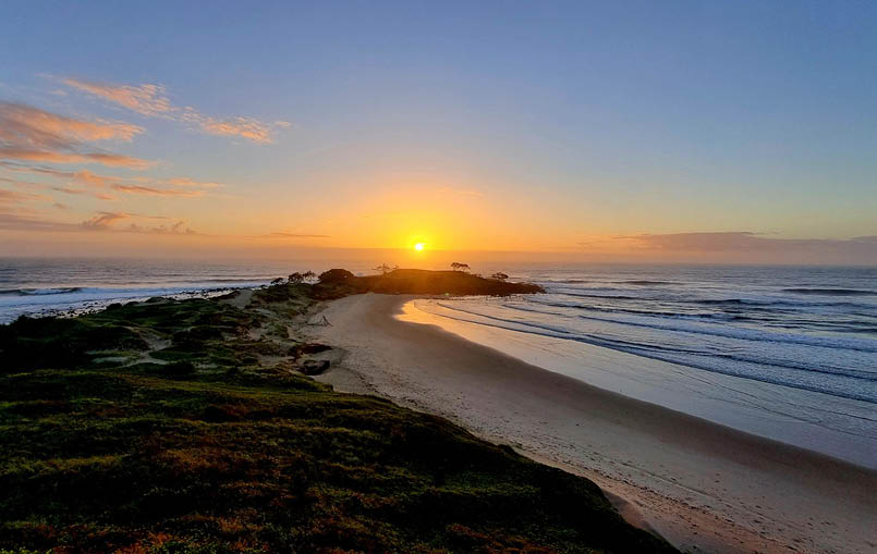
Day 1: Angourie Back Beach
5
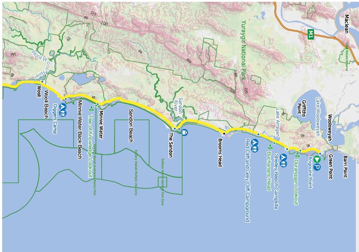

This map is © Bushwalk.com and is created using data © OpenStreetMap contributors
Road, four-wheel drive track, walking track (treed)Main track, side trip, alternative routeCliff, major contour line, minor contour line (20 metre interval)Lake, river, waterfall or creek


Angourie Point to Wooli
0 2 4 6 8 10km


Start of the walk
Parking
Campsite
Toilet


6 | Bushwalk June 2024
Along the firm low tide sands of Angourie Back Beach, it didn’t take long to settle into a comfortable stride. I walk with poles, which makes walking on sand much more relaxed The regular movement of arms and legs, combined with the rhythmic sounds of the waves and wind rapidly puts me into that peaceful, serene, almost meditative state that all solo hikers know and love.
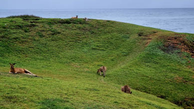
I soon reached Duranggan Lookout and enjoyed the kangaroos having an early morning graze nearby. I feel as if I am in a beautifully produced tourist ad for Australia - kangaroos, a glorious view, an idyllic surf, wrapped by national park and enjoying some fine steaming black coffee from the Yamba café that I cleverly poured into my thermos… just sublime.
The sun inched higher and the day moved on. I rounded One Man Bluff –a place that the Yaegl people must have enjoyed for tens of thousands of years before my little sojourn. I wandered along 'pretty as a picture' Little Shelley Beach. Next was Shelley Headland
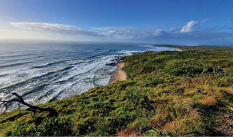
Day 1: Most of the Yuraygir Walk is very straightforward with easy beaches and well-made tracks
Day 1: Looking south towards Shelley Head from One Man Bluff
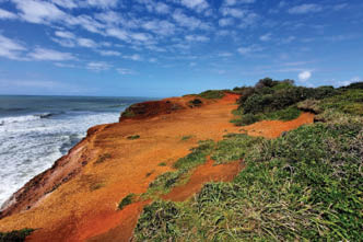
Day 1: Red Cliff
7
and its delightful campground followed by a scramble down to Shelly Head Beach - a charming little cove enhanced by the Shelley Caves that can be accessed at a lowish tide – simply magical!
The track then returned to a stretch of sand at Caves Beach before arriving at Buchanans Head. Plumbago Beach offered another few kilometres of softish sand. It’s no trudge though; walking towards Red Cliff with its glowing cinnabar colouring made for a spectacular motivational target on this segment of the day’s walk.
Red Cliff and Grey Cliff both have NPWS camping areas and would both be mighty fine places to pitch a tent. I was staying in comfort tonight though, so I set off for the final leg along Main Beach to the delightful town of Brooms Head. The settlement there consisted of some houses, a caravan park, a café, a bowling club and a small general store with attached accommodation and my abode for the night. A hot shower, a cold beer and one very happy coastal walker.
Day 2: Brooms Head to Minnie Water18km, 5 hrsSunrise over beautiful Brooms Head was an ideal way to start the day. Then it was down to the beach along a well-made track for the 9 km stroll to The Sandon. Plenty of birdlife along this stretch, most impressively the many white-bellied sea eagles who sometimes feel like my totem bird for the walk. They swooped and soared past me and always seemed to be heading south, scouting the way. Occasional dingo tracks near the dunes, and a dingo-mauled wallaby along the beach, but no sign of dingo stalkers (at least none that I know of!) anywhere along the walk.
The NSW National Parks and Wildlife Service (NPWS) website provides contact details for a boat to take you across the Sandon River. It’s a great service and reasonably priced - I paid $20. While I carried a small inflatable pack raft, I took the easy way out. It's a relatively short crossing and looks perfectly fine to do by raft with an incoming tide – possibly even swimmable – but then again, with plenty of shark sightings in the area, a $20 'tinny' ride seems like a bargain to me.
Day 2: Crossing Brooms Head

8 | Bushwalk June 2024
Once across the Sandon, it was another 12kms or so to Minnie Water along Sandon and Illaroo Beaches – more postcard-perfect walking with only the gulls, shorebirds and occasional eagle for company. Beaches are always easier when the tide is low, but I had to do a bit of soft sand trudging on an incoming high tide for this section of the walk. Once 'the tide turned', the going was much easier and I was happy to have lived through an idiom, so to speak.
Minnie Water was another pleasant settlement with a sophisticated general store (note that it closed at 4pm). There are a range of provisions available there, including fine coffee and some gourmet food options. I stayed in a cabin in the caravan park – possible to book one-night stays on weeknights, although you might have to call direct, as web bookings usually state a two-night minimum.
There’s not much in Minnie Water other than exquisite natural beauty and wonderful people... can't complain!
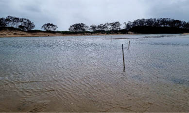
Day 3: Minnie Water to Wooli16km, 4 hrsI again began by immersing myself in the sunrise. This time at the Tree of Knowledge Lookout (amazing view, but sadly I'm none the wiser), and then following a delightful trail down to Minnie Water Back Beach. A ‘back’ beach generally faces a different direction from the ‘main’ beach and is usually more exposed to larger swells (so in this part of the coast, facing a more southerly direction). Anyway, the back beach was a grand walk in the early morning light before arriving at Diggers Camp; a refreshing highlight being the permanent freshwater showers that run down from the peculiarly named (for Australia) Lake Hiawatha.
Nearby exquisite Boorkoom Campground leads on to the Wilsons Headland Track, which is definitely on the nomination list for the headland Oscars - just an incredible place. After a few small unnamed beaches, I had another soft sand trudge along Wooli Beach with the high tide approaching - nothing too
Day 3: Tree of Knowledge sunrise
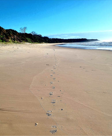
Day 3: Minnie Water Back Beach. Leave nothing but footprints
9
This map is © Bushwalk.com and is created using data © OpenStreetMap contributors
Road, four-wheel drive track, walking track (treed)Main track, side trip, alternative routeCliff, major contour line, minor contour line (20 metre interval)Lake, river, waterfall or creek
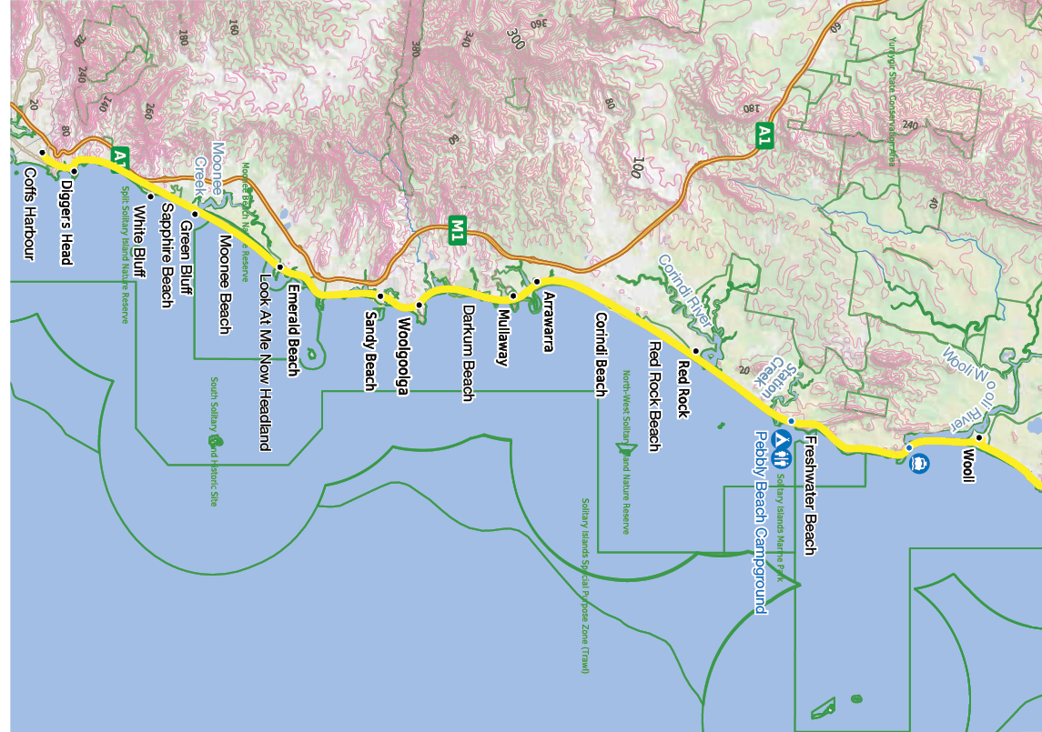
Wooli to Coffs Harbour
0 2 4 6 8 10km
Start of the walk
Parking
Campsite
Toilet
10 | Bushwalk June 2024
difficult, and the lovely Wooli River Lodges on the bank of the Wooli Wooli River provided perfect therapy at the end of the walk.
Wooli is the largest town on the Yuraygir Walk and a delightful place to spend the evening. The local hotel has a gourmet touch with an ex-chef from Australia’s longest-running Italian restaurant, having made a sea change to the town – unusual to be enjoying five-star food on a five-star trek!
Day 4: Wooli to Red Rock22km, 6 hrsI started before sunrise with a NPWS boat across the Wooli Wooli River – this is a more significant crossing than The Sandon, but once again, mobile phone details are available on the NPWS website. The boat captain also mentioned that he is able to arrange a crossing of the Corindi River at Red Rock, which might be worth enquiring about. This last day of Yuraygir is quite tide-dependent, so depending on your starting point and the day’s tide, you might be grateful for a boat at Red Rock.
The first part of the day 4 walk was wild and remote – stunningly beautiful, but probably the only slightly tricky bit of the whole Yuraygir Walk; nothing too difficult, just some climbs, a few slippery bits, some sharpish rock platforms and the occasional need to make a ‘high road or low road’ decision.
It was a joy for me to finally arrive at Freshwater Beach and take a comfortable stroll along the sand, followed by a short trek over the headland to the campground at Pebbly Beach. Then a thigh-deep wade across Station Creek and more pleasant sand-walking past Barcoongere.
A cooling southerly was blowing up, Red Rock was a vermillion sentinel in the distance, and I had a superlative hour or so of iconic beach walking with everything ‘just so’. And then, as happens in life, the cooling southerly became a gale, the cloudy coolness turned to driving rain, and when I finally reached the Corindi River, it was peak high tide.
Of course, I could have waited a few hours for the tide to recede, but being on an exposed sandbar in the middle of a southerly gale,
Day 4: Successfully across the Wooli Wooli River
Day 4: Station Creek
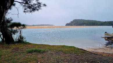
Day 4: Corindi River
11
Day 5: Little Red Rock
with warmth and civilisation in sight, made the prospect less than ideal. I put on my swimmers and navigated much of the way over the river on sand bars with my pack on my head, disturbing some slumbering sting rays in the process. Finally, I gave in, inflated my pack raft in the wild winds and put my gear inside while I swam the final channel.... It would be possible to swim the deep channel with your pack finely balanced on your head – not ideal, but definitely not impossible. As noted above, it is possible to arrange a boat passage across the Corindi River when you arrange your Wooli crossing. All that being said, at a lowish tide on a normal day, the Corindi River should not be too difficult to cross chest-deep.
I should mention the Woopi Connect App. It provides an on-demand public transport service in the areas north of the Coffs Harbour bus network. It works like Uber but at public transport prices. It is a great option if you
are completing the Yuraygir Walk at Red Rock, but want to get to, say, Woolgoolga to connect with long-distance transport.
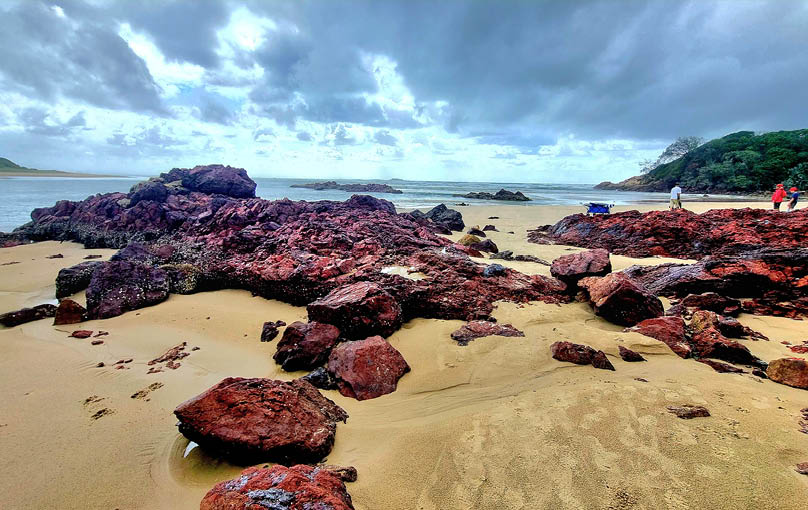
Day 5: Red Rock to Woolgoolga17km, 5 hrsRed Rock (made of red jasper) marks the official southern terminus of the Yuraygir Walk, so today, I moved onto the northern section of the Solitary Islands Way. The walk from Red Rock to Woolgoolga includes crossing the technical border between the Coral Sea and the Tasman Sea, as well as Red Rock Little and Big Beaches, Pipeclay Beach and Corindi Headland. After Corindi is wonderful Arrawarra Beach and its sensational headland, then Ocean View Beach, Mullaway Beach, Mullaway Headland, Cabins Beach, Darkum Beach, Safety Beach and finally Woolgoolga with its Sikh connections and amazing Indian restaurants - what a selection! Just a magnificent series of beaches, headlands and sensational coastal scenery.

12 | Bushwalk June 2024
There are plenty of ICOLLS (intermittently closed and open lakes and lagoons) along the way. Most are closed at present, and the few open ones were a knee-deep wade. There are a variety of places for water and snacks in this section of the walk, which makes planning and provisioning much easier.
I stayed the night at Woopi Backpackers – a delightful establishment primarily filled with young working holidaymakers doing their visa-required time on farms in the hinterland. They provide great company, and the friendly relaxed atmosphere (and quirky front bar) make it highly recommended.
Day 6: Woolgoolga to Coffs Harbour33km, 8 hrsAnd so, to the final day for this phase of my NSW coast walk from Woolgoolga to Coffs Harbour. Coffs is known as a place where the mountains meet the sea - and while they are Aussie-size mountains (hills with delusions of grandeur), it certainly made for amazing scenery while ambling along the beaches.
It was a longish walk of 33 kilometres or so (and the official guides recommend doing this over two days), but there was 'civilisation' along the way for refuelling stops. This part of the Solitary Islands Way is an incredible stretch of coastline and includes Woolgoolga Back Beach, Dammerel Head, Sandy Beach, Bare Bluff, Fiddamans Beach, Diggers Point, Emerald Beach, Serenity Bay and Shelly Beach.
My lunch stop was at the wonderfully named Look At Me Now Headland with its myriad kangaroos lazing about on the enormous grassy headland. Moonee Beach, Green Bluff, Sapphire Beach, White Bluff, Campbells Beach and Pelican Beach are next. Pelican Beach is difficult to access except at a very low tide. Otherwise, it is a long trip back up to the road to walk around the resorts that restrict access to the beach. Then it’s on to Hills Beach, Korora Beach, Charlesworth Bay Beach, Little Diggers Beach, Diggers Beach, Gwiddy Beach and Macauleys Headland.
The town of Coffs Harbour was now well and truly in sight and after another few kilometres via Horne Beach, Park Beach and North Wall
Beach I was finally at Coffs Harbour Jetty Beach. Outstanding variety, great tracks over the headlands and just enough bush-bashing to wear a tired bushwalker out.
I was doing the walk on St Patrick's Day, and it got me thinking about my long-ago ancestors from County Leitrim in Ireland. They jumped on a ship into the unknown of New South Wales nearly 200 years ago. It must have felt like going to Mars - imagine the goodbyes to loved ones, knowing you would never see them again. I feel so lucky they made that choice, however, even though it was no doubt forced by poverty and desperation. I feel truly blessed to have this astonishing thousand-mile coastline almost as a birthright. Every bit of beach is publicly owned and accessible, the geological variation is incredible, the wildlife, both terrestrial and marine, is amazing, and the restorative effect of simply being by the sea is exquisite.
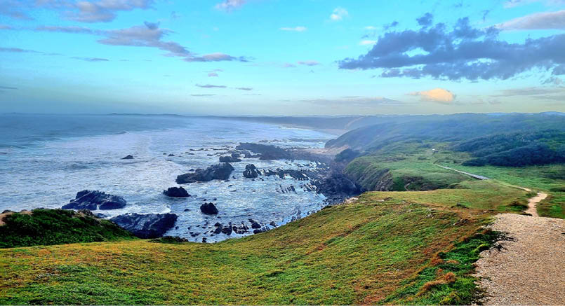
Day 6: Look At Me Now Headland
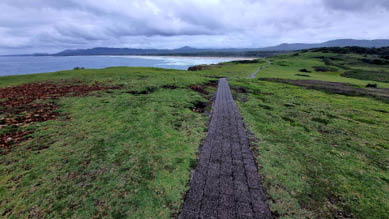
Day 6: Follow the grey brick road
13
I arrived in Coffs Harbour as darkness fell. A swim and a shower, and then I sank a Guinness or two in honour of those Irish forebears and their choices. I made my way to Coffs Harbour Station. I caught the night
train back to Sydney and, after a blissful week of 'coast-questing' through Yuraygir National Park and the Solitary Islands Way, I agree with Helen Keller 'Life is either a daring adventure or nothing ...'.
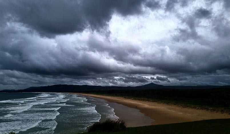
Day 6: It’s not all blue skies and fair weather!Looking south from Look At Me Now Headland
Greg grew up in Sydney but lived for many years in SE Asia. He has now returned home to Sydney and loves exploring Australia’s magnificent bushwalks, parks, coasts and waterways. When he’s not bushwalking or mountain bike-riding, he works in education for Deloitte and Ecctis UK.


<

14 | Bushwalk June 2024